Modeling the Mediterranean with MITgcm
story by Helen Hill

Researcher Gianmaria Sannino, a staff scientist in the Energy and Environment Modeling Technical Unit of the Italian National Agency for New Technologies, Energy and Sustainable Economic Development (ENEA) has been using MITgcm for several years to model different aspects of the Mediterranean circulation. Most recently he has been collaborating with José-Carlos Sánchez-Garrido (University of Malaga) and others, to better understand the strongly three-dimensional circulation of the sill system near Gibraltar.

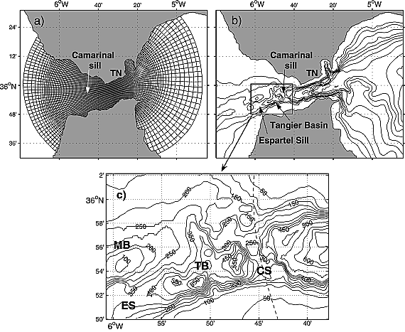
Figure 1 (a) Computational grid used in the numerical experiment (for the sake of clarity, only 2% of the grid points are shown). The locations of Camarinal Sill and Tarifa Narrows (TN) are indicated. (b) Bottom topography of the Strait of Gibraltar (isobaths are shown every 100 m). (c) Detailed bottom topography map in the area of the Camarinal Sill (CS), Tangier Basin (TB), Espartel Sill (ES), and Majuan Bank (MB). Dashed line indicates the cross-strait section over CS – Sánchez-Garrido et al. (2012)
The model domain extends from 6.3°W to 4.78°W and was discretized by a non-uniform curvilinear orthogonal grid of 1440 by 210 points (Figure 1a). Spatial resolution along the longitudinal axis of the strait, Dx, (across the strait axis, Dy,) ranges between 46 and 63 m (175–220 m) in the CS area and mesh size is always less than 70 m (340 m) in the middle of the strait between Espartel Sill (the western-most sill of Gibraltar) and the Camarinal Sill, and less than 70 m (200 m) between Camarinal Sill and Tarifa Narrows, the narrowest section of the strait. To adequately resolve the pycnocline the model had 53 vertical z levels with a thickness of 7.5 m in the upper 300 m gradually increasing to a maximum of 105 m for the remaining 13 bottom levels.
Model topography (Figures 1b and 1c) was obtained by merging the ETOPO2 bathymetry [NOAA, 2006] with the very high resolution bathymetry chart of Sanz et al., 1991*. No-slip conditions were imposed at the bottom and lateral solid boundaries.
MITgcm was used to solve the fully nonlinear, nonhydrostatic Navier–Stokes equations under the Boussinesq approximation for an incompressible fluid with a spatial finite-volume discretization on a curvilinear computational grid. The model formulation included implicit free surface and partial step topography.
The team chose the third-order direct space-time flux limited tracer advection scheme of Hundsdorfer et al., (1995), which is unconditionally stable and does not require additional diffusion. For further implementation details see Sánchez-Garrido et al. (2012).
The goal of the modeling study was an investigation of the baroclinic response to barotropic tidal forcing in the Camarinal Sill area, within the Strait of Gibraltar.
In response to the irregular bottom topography, variable background stratification, the teams results revealed a strongly three-dimensional regime including a complex baroclinic response under relatively moderate flood tidal currents, the formation of internal hydraulic jumps upstream of the sill, internal cross waves close to the channel walls, and a plunging pycnocline at the lee side of the sill crest.
These structures were found to exhibit significant cross-channel spatial dependence and could appear to be aligned together across the channel. This fact makes their identification difficult from the surface pattern captured by remote sensing images. Under strong barotropic forcing (spring tides) the upstream hydraulic jumps are shifted to the lee side of Camarinal Sill, where a single internal hydraulic jump is formed. Significant first- and second-mode hydraulic jumps are also generated near smaller secondary sills in Tangier basin, thus extending the occurrence of intense water mixing and energy dissipation to other zones of the strait. To find out more ask Gianmaria.
Internal Tide Strait of Gibraltar
This video shows the evolution of the interface layer (between Atlantic water and Mediterranean water) as simulated by MITgcm in non-hydrostatic configuration. The main 6 tidal component are considerd – video courtesy of G. Sannino. More of Sannino’s MITgcm Mediterranean Movies here.
Related Publications:
- Artale et al. (2010) An atmosphere–ocean regional climate model for the Mediterranean area: assessment of a present climate simulation, Climate Dynamics,Volume 35, Number 5 (2010), 721-740, doi: 10.1007/s00382-009-0691-8
- Carillo, A. G. Sannino, V. Artale, P. Ruti, S. Calmanti. A. Dell’Aquila (2012) Steric sea level rise over the Mediterranean Sea: present climate and scenario simulations. Climate Dynamics, 10.1007/s00382-012-1369-1.
- Sanchez-Garrido et al., (2012) Numerical modelling of three-dimensional stratified tidal flow over Camarinal Sill, Strait of Gibraltar – In Press at JGR, doi: 10.1029/2011JC007093
- Sannino et al. (2009) An eddy-permitting model of the Mediterranean Sea with a two-way grid refinement at the Strait of Gibraltar, Ocean Modelling, Volume 30, Issue 1, 2009, Pages 56–72, doi: 10.1016/j.ocemod.2009.06.002
*Sanz, J. L., J. Acosta, M. Esteras, P. Herranz, C. Palomo, and N. Sandoval (1991), Prospección geofísica del Estrecho de Gibraltar (resultados del programa Hércules 1980–1983), Publ. Espec. Inst. Esp. Oceanogr., 7, 48 pp., Span. Inst. of Oceanogr., Madrid.

