Ocean forecasting in the Gulf of Mexico
story by Helen Hill

This month we focus on several recent papers that have used MITgcm and its adjoint to perform state estimates and explore its ocean forecasting capabilities in the Gulf of Mexico. Researchers involved include Ibrahim Hoteit and Thomas Höllt working at KAUST and Ganesh Gopalakrishnan (Scripps).
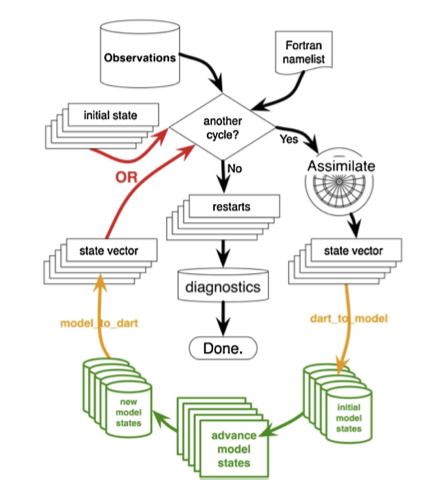
A key player in the Gulf of Mexico’s circulation is the powerful northward flowing loop current through the Yucatan channel, source of irregularly-shed warm-core eddies. Hoteit et al (2013) describes the development of an ensemble Kalman filter -based ocean data assimilation system aimed at predicting this loop current. Their system, which integrates the Data Assimilation Research Testbed (DART) with MITgcm, supports the assimilation of a broad array of ocean observations, using an ensemble approach to solve nonlinear assimilation problems. Using an eddy-resolving (1/10th degree) model configuration, the team perform assimilation experiments during a documented strong loop current eddy separation event, by constraining the model sequentially with weekly satellite sea surface temperature and altimetry data. For all the details see A MITgcm/DART ensemble analysis and prediction system with application to the Gulf of Mexico.

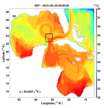
(MITgcm) Model SST on the “target day” for the loop current eddy separation adjoint experiment (from Gopalakrishnan et al., 2013b)
Gopalakrishnan et al, 2013 (doi:10.1002/jgrc.20240) focuses on which regions and features control the evolution of the loop current and eddy shedding in the Gulf of Mexico. Computing forward and adjoint sensitivities with respect to previous model state, open boundary conditions, and atmospheric forcing using MITgcm and its adjoint the authors conclude that the adjoint sensitivities can be used to successfully produce dynamically consistent ocean state estimates for analysis and prediction of the Gulf circulation.
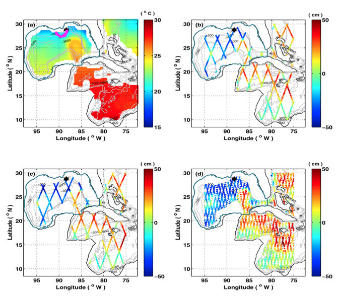
A companion paper Gopalakrishnan et al, 2013 (doi:10.1002/jgrc.20239) reports on the development of an MITgcm-based ocean state estimate and loop current forecast tool. Gopalakrishnan’s and co-authors use the adjoint method to match the model evolution to observations by adjusting model temperature and salinity initial conditions, open boundary conditions, and atmospheric forcing fields. They fit the model to satellite -derived along-track sea surface height, separated into temporal mean and anomalies, and gridded sea surface temperature for 2 month periods, and use the optimized state at the end of the assimilation period to initialize the forecast for two months. Model performance is then evaluated by computing model-observation root-mean-square difference during both the hindcast and forecast periods.
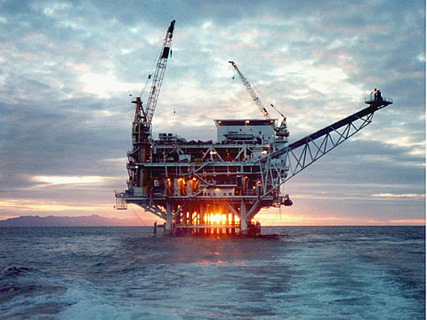
Finally, besides meteorological hazards, offshore structures in the Gulf of Mexico, such as those used for oil exploration, are vulnerable to marine hazards caused by the traverse of warm core loop current eddies. The oil and gas industries therefore rely on accurate ocean forecasting systems in planning their operations.
With this in mind, another multi-institutional effort, has been using MITgcm as a testbed for operational ocean forecasts with a view to guiding placement of structures offshore. By monitoring sea-surface elevation changes in MITgcm simulations as an indicator of loop current eddy movement Höllt et al, 2013 (also among its co-authors Gopalakrishnan and Hoteit) reports the development of a “novel integrated visualization system that enables the interactive planning of both the placement and operation of offshore structures”.
The Researchers
Ibrahim Hoteit is an Assistant Professor of Earth Sciences and Engineering, and Applied Mathematics and Computational Science at King Abdullah University of Science and Technology (KAUST). A former member of ECCO, who has published with several previously featured MITgcmers among them Patrick Heimbach and Sara Zedler, Hoteit’s research interests include the development of advanced methods for data assimilation and inverse problems; modeling, analysis and prediction of the Red Sea and Persian Gulf circulation; uncertainty quantification and estimation of ocean models mixing parameters; and storm surge forecasting using nonlinear Kalman filtering. Hoteit started using the MITgcm in 2002 when he began his postdoc at Scripps as part of the ECCO consortium. When not MITgcming he likes fishing and snorkeling in the Red Sea.
Ganesh Gopalakrishnan is an assistant project scientist in the Physical Oceanography Research Division of Scripps Institution of Oceanography, UCSD interested in ocean modeling, data assimilation and observational oceanography. He has been using MITgcm and its Adjoint since 2008 when he started his postdoc at Scripps. When not MITgcming he says he likes to take long walks – definitely a healthy antidote to coding!
Thomas Höllt recently finished his PhD in KAUST’s Geometric Modeling and Scientific Visualization Center where he is now a postdoc. Interested in scientific visualization, computer graphics, GPGPU, and mobile application development, he has been visualizing MITgcm data since 2011.
References
Gopalakrishnan, G., B. D. Cornuelle, I. Hoteit, D. L. Rudnick, and W. B. Owens (2013) State estimates and forecasts of the loop current in the Gulf of Mexico using the MITgcm and its adjoint, Journal of Geophysical Research Oceans, doi:10.1002/jgrc.20239
Gopalakrishnan, G., B. D. Cornuelle, and I. Hoteit (2013) Adjoint sensitivity studies of loop current and eddy shedding in the Gulf of Mexico. Journal of Geophysical Research Oceans, doi:10.1002/jgrc.20240
Höllt,T., A. Magdy, G. Chen, G. Gopalakrishnan, I. Hoteit, C.D. Hansen, and M. Hadwiger (2013) Visual Analysis of Uncertainties in Ocean Forecasts for Planning and Operation of Off-Shore Structures. In Proceedings of IEEE Pacific Visualization Symposium 2013, pages 185—192.
Hoteit, I., T. Hoar, G. Gopalakrishnan, N. Collins, J. Anderson, B. D. Cornuelle, A. Köhl, and P. Heimbach (2013) A MITgcm/DART ensemble analysis and prediction system with application to the Gulf of Mexico, Dynamics of Atmospheres and Oceans, Volume 63, September 2013, Pages 1–23, doi: 10.1016/j.dynatmoce.2013.03.002
Related Media
Visual Analysis of Uncertainties in Ocean Forecasts for Planning and Operation of Off-Shore Structures from Thomas Höllt on Vimeo.
Visualizations of Sea Surface Height in the GoM from MITgcm (Video credit: Hoteit Group, KAUST)


