 |
 |
|||||||||||
 |
|
|||||||||||
 |
 |
|||||||||||


|
Next: 2.10.6 Vertical grid Up: 2.10 Spatial discretization of Previous: 2.10.4 Grid initialization and Contents Subsections
|
|
The model domain is decomposed into tiles and within each tile a
quasi-regular grid is used. A tile is the basic unit of domain
decomposition for parallelization but may be used whether parallelized
or not; see section ![[*]](crossref.png) for more details. Although the
tiles may be patched together in an unstructured manner
(i.e. irregular or non-tessilating pattern), the interior of tiles is
a structured grid of quadrilateral cells. The horizontal coordinate
system is orthogonal curvilinear meaning we can not necessarily treat
the two horizontal directions as separable. Instead, each cell in the
horizontal grid is described by the length of it's sides and it's
area.
for more details. Although the
tiles may be patched together in an unstructured manner
(i.e. irregular or non-tessilating pattern), the interior of tiles is
a structured grid of quadrilateral cells. The horizontal coordinate
system is orthogonal curvilinear meaning we can not necessarily treat
the two horizontal directions as separable. Instead, each cell in the
horizontal grid is described by the length of it's sides and it's
area.
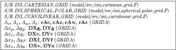
The grid information is quite general and describes any of the available coordinates systems, cartesian, spherical-polar or curvilinear. All that is necessary to distinguish between the coordinate systems is to initialize the grid data (descriptors) appropriately.
In the following, we refer to the orientation of quantities on the computational grid using geographic terminology such as points of the compass. This is purely for convenience but should note be confused with the actual geographic orientation of model quantities.
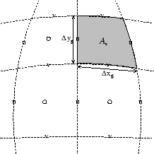
Fig. 2.9a shows the tracer cell (synonymous with the
continuity cell). The length of the southern edge,
![]() ,
western edge,
,
western edge,
![]() and surface area,
and surface area, ![]() , presented in the
vertical are stored in arrays DXg, DYg and rAc.
The ``g'' suffix indicates that the lengths are along the defining
grid boundaries. The ``c'' suffix associates the quantity with the
cell centers. The quantities are staggered in space and the indexing
is such that DXg(i,j) is positioned to the south of rAc(i,j) and DYg(i,j) positioned to the west.
, presented in the
vertical are stored in arrays DXg, DYg and rAc.
The ``g'' suffix indicates that the lengths are along the defining
grid boundaries. The ``c'' suffix associates the quantity with the
cell centers. The quantities are staggered in space and the indexing
is such that DXg(i,j) is positioned to the south of rAc(i,j) and DYg(i,j) positioned to the west.
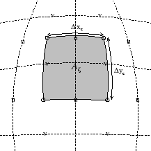
Fig. 2.9b shows the vorticity cell. The length of the
southern edge,
![]() , western edge,
, western edge,
![]() and surface
area,
and surface
area, ![]() , presented in the vertical are stored in arrays DXg, DYg and rAz.
The ``z'' suffix indicates that the lengths are measured between the
cell centers and the ``
, presented in the vertical are stored in arrays DXg, DYg and rAz.
The ``z'' suffix indicates that the lengths are measured between the
cell centers and the ``![]() '' suffix associates points with the
vorticity points. The quantities are staggered in space and the
indexing is such that DXc(i,j) is positioned to the north of
rAc(i,j) and DYc(i,j) positioned to the east.
'' suffix associates points with the
vorticity points. The quantities are staggered in space and the
indexing is such that DXc(i,j) is positioned to the north of
rAc(i,j) and DYc(i,j) positioned to the east.
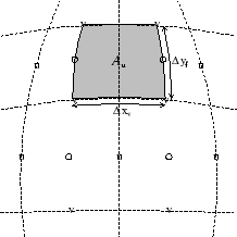
Fig. 2.9c shows the ``u'' or western (w) cell. The length of
the southern edge,
![]() , eastern edge,
, eastern edge,
![]() and
surface area,
and
surface area, ![]() , presented in the vertical are stored in arrays
DXv, DYf and rAw.
The ``v'' suffix indicates that the length is measured between the
v-points, the ``f'' suffix indicates that the length is measured
between the (tracer) cell faces and the ``w'' suffix associates points
with the u-points (w stands for west). The quantities are staggered in
space and the indexing is such that DXv(i,j) is positioned to
the south of rAw(i,j) and DYf(i,j) positioned to the east.
, presented in the vertical are stored in arrays
DXv, DYf and rAw.
The ``v'' suffix indicates that the length is measured between the
v-points, the ``f'' suffix indicates that the length is measured
between the (tracer) cell faces and the ``w'' suffix associates points
with the u-points (w stands for west). The quantities are staggered in
space and the indexing is such that DXv(i,j) is positioned to
the south of rAw(i,j) and DYf(i,j) positioned to the east.
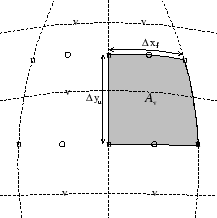
Fig. 2.9d shows the ``v'' or southern (s) cell. The length of
the northern edge,
![]() , western edge,
, western edge,
![]() and
surface area,
and
surface area, ![]() , presented in the vertical are stored in arrays
DXf, DYu and rAs.
The ``u'' suffix indicates that the length is measured between the
u-points, the ``f'' suffix indicates that the length is measured
between the (tracer) cell faces and the ``s'' suffix associates points
with the v-points (s stands for south). The quantities are staggered
in space and the indexing is such that DXf(i,j) is positioned to
the north of rAs(i,j) and DYu(i,j) positioned to the west.
, presented in the vertical are stored in arrays
DXf, DYu and rAs.
The ``u'' suffix indicates that the length is measured between the
u-points, the ``f'' suffix indicates that the length is measured
between the (tracer) cell faces and the ``s'' suffix associates points
with the v-points (s stands for south). The quantities are staggered
in space and the indexing is such that DXf(i,j) is positioned to
the north of rAs(i,j) and DYu(i,j) positioned to the west.
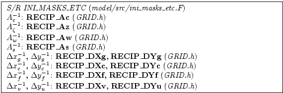
2.10.5.1 Reciprocals of horizontal grid descriptors
Lengths and areas appear in the denominator of expressions as much as in the numerator. For efficiency and portability, we pre-calculate the reciprocal of the horizontal grid quantities so that in-line divisions can be avoided.
For each grid descriptor (array) there is a reciprocal named using the prefix RECIP_. This doubles the amount of storage in GRID.h but they are all only 2-D descriptors.
2.10.5.2 Cartesian coordinates
Cartesian coordinates are selected when the logical flag usingCartesianGrid in namelist PARM04 is set to true. The grid spacing can be set to uniform via scalars dXspacing and dYspacing in namelist PARM04 or to variable resolution by the vectors DELX and DELY. Units are normally meters. Non-dimensional coordinates can be used by interpreting the gravitational constant as the Rayleigh number.
2.10.5.3 Spherical-polar coordinates
Spherical coordinates are selected when the logical flag usingSphericalPolarGrid in namelist PARM04 is set to true. The grid spacing can be set to uniform via scalars dXspacing and dYspacing in namelist PARM04 or to variable resolution by the vectors DELX and DELY. Units of these namelist variables are alway degrees. The horizontal grid descriptors are calculated from these namelist variables have units of meters.
2.10.5.4 Curvilinear coordinates
Curvilinear coordinates are selected when the logical flag usingCurvilinearGrid in namelist PARM04 is set to true. The grid spacing can not be set via the namelist. Instead, the grid descriptors are read from data files, one for each descriptor. As for other grids, the horizontal grid descriptors have units of meters.
Next: 2.10.6 Vertical grid Up: 2.10 Spatial discretization of Previous: 2.10.4 Grid initialization and Contents mitgcm-support@dev.mitgcm.org
| Copyright © 2002 Massachusetts Institute of Technology |


